
The question I hear most from new customers isn't about wiring or tire pressure. It's this: how do you find spots out in the woods or the desert that are safe, legal, and actually good?
So I sat down with my friend Ken of Hot Visuals (@iamkenjo) to compare notes. Ken gets the same question constantly from people who follow his trips. He's turning his answer into a passion project: a map of places you can camp within an hour or so of Los Angeles, from Ojai to Angeles Crest to the beaches near Malibu. Spots people drive past without realizing they're right in their own backyard.
It turns out we find camps almost the same way. No secret tools. A simple, repeatable method that works anywhere, whether it's your first night out or your five-hundredth.
The method at a glance
Start wide and narrow it down: from "somewhere near where I'll be tonight" to one spot you've checked is legal, level, and worth it.
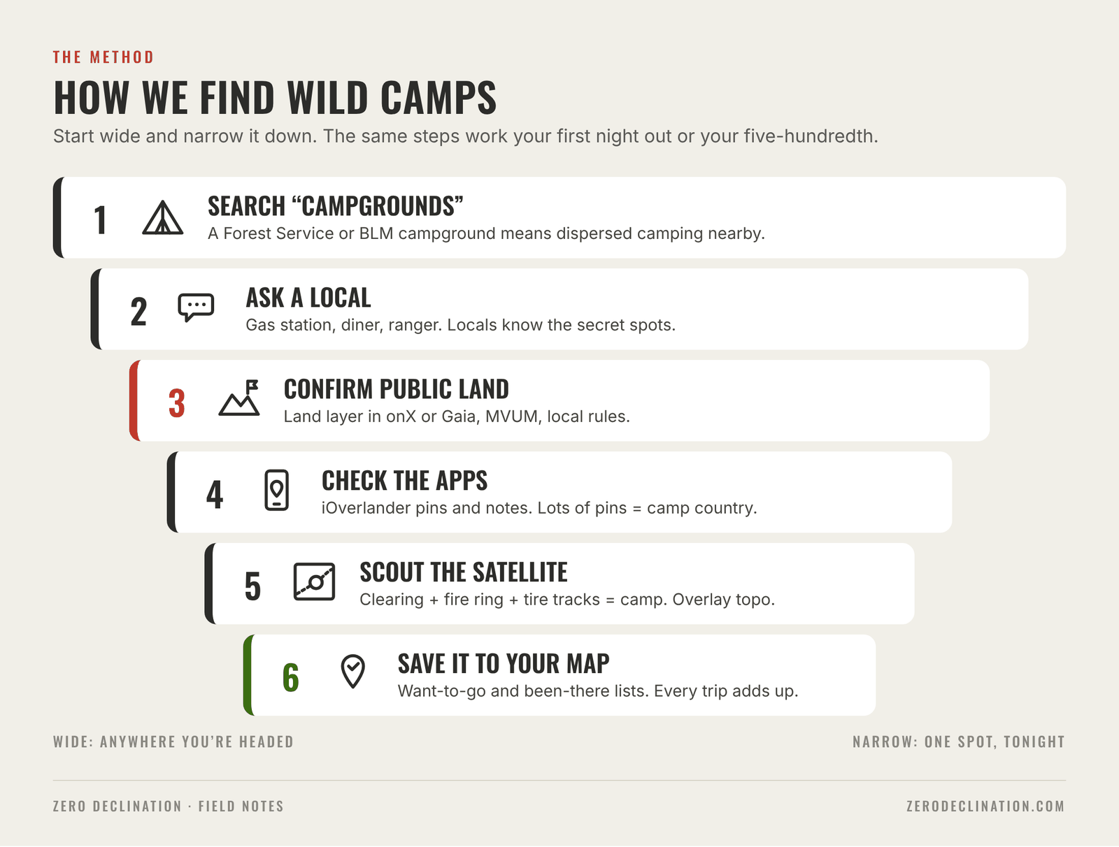
1.Search for a campground, even if you won't stay in one
Ken's first move is the simplest one: open Google Maps and type "campgrounds" near wherever you'll be at sundown. Headed to Reno with no plan and Mammoth is the halfway point? Start there.
If you've never camped before, actually staying in that campground is a great first night. Bathrooms, neighbors, zero guesswork.
But even if you want a spot to yourself, the search still works, because of what it tells you about the land around it:
- A US Forest Service or BLM campground is a strong sign you're on public land that allows dispersed camping. There's almost always a spot nearby. You just can't camp at the campground without paying, or right next to it (more on that below).
- State and national parks are different. Most don't allow camping outside designated sites. A state park campground on the map doesn't mean free camping around it.
2.Ask a local
The best spots aren't in any app. They're in the heads of the people who live there.
The guy at the gas station. The person next to you at the diner counter wearing a fishing shirt. The ranger at the district office. Ask them, "Where's your favorite place to camp around here?" Most people want to share. Those are usually the secret spots that nobody else knows about, and they end up being Ken's favorites and mine.
The campground search is just the on-ramp. It gets you into the area, and that's where you meet the people who know.
Before you park: is it public land?
In the video I promised we'd cover this, and then we never got back to it. So here it is. A great-looking clearing is only a camp if you're allowed to be there. In the West, that usually means National Forest (US Forest Service) or BLM (Bureau of Land Management) land, where free "dispersed" camping outside of campgrounds is generally allowed.
How to tell
- Turn on a land layer. onX Offroad and Gaia GPS can color in who owns the land: Forest Service, BLM, state, private. This is the fastest check, and the one I use most.
- Download the Motor Vehicle Use Map (MVUM). Every Ranger District publishes one. It shows which Forest Service roads are open to vehicles; if a road isn't on the MVUM, it isn't open to drive. They're free in the Avenza Maps app and work offline. Check the legend for what each forest allows for pulling off to camp.
- Call or stop by the district office. Rules, closures, and fire restrictions change by forest and by season. A two-minute call settles it.
The usual rules
These are typical, not universal. Every forest and BLM field office can set its own, so check locally.
| Rule | National Forest (USFS) | BLM land |
|---|---|---|
| Stay limit | Usually 14 days, shorter in some areas | 14 days in any 28-day period, then move 25+ miles |
| Distance from water | Commonly 100–200 ft for camps, fires, and waste | Commonly 200 ft |
| Near developed sites | Not allowed next to campgrounds, picnic areas, or trailheads | Use marked sites inside developed campgrounds |
| Getting to your spot | Only on roads shown on the MVUM; some forests cap distance off the road (e.g., 300 ft) | Stay on existing roads and ways; many offices limit how far off the road you can go |
| Fires | Check restrictions; California requires a free campfire permit | Check restrictions before every trip |
And always: pack out everything you pack in, use existing fire rings, and drive only where others already have. The spots we love stay open because people treat them well.
Sources: USFS Pacific Southwest Region, Dispersed Camping · Apache-Sitgreaves NF, Dispersed Camping Guidelines · Humboldt-Toiyabe NF, Motor Vehicle Use Maps · BLM Idaho Camping Guidelines (2022)
3.Check the apps
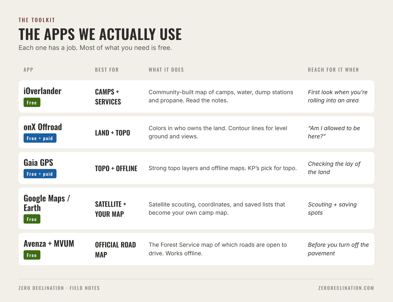
Ken and I both use pretty much all of them, but each has a job.
- iOverlander: the go-to. It's free and built by the community. It shows camps, plus water fill-ups, dump stations, propane, and other services. The best part is the notes: "Fine for one night, keep it quiet, there are houses nearby." That context is gold.
- onX Offroad and Gaia GPS: topo and land status. Ken leans on onX; I like Gaia. Either one shows contour lines (is it level? is there a view?) and who owns the land.
- Google Maps and Google Earth: scouting and your own map. Ken punches coordinates into Google Earth to see exactly what's there. More on both in the next two steps.
Here's how I use iOverlander even when I don't stay at any of its spots: lots of pins in an area means it's camp-friendly country. If the map is busy where I'm headed, I know I'll find something nearby.
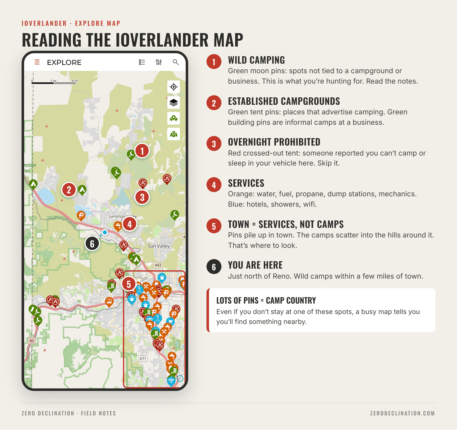
Full icon key: iOverlander category legend.
4.Scout it from satellite
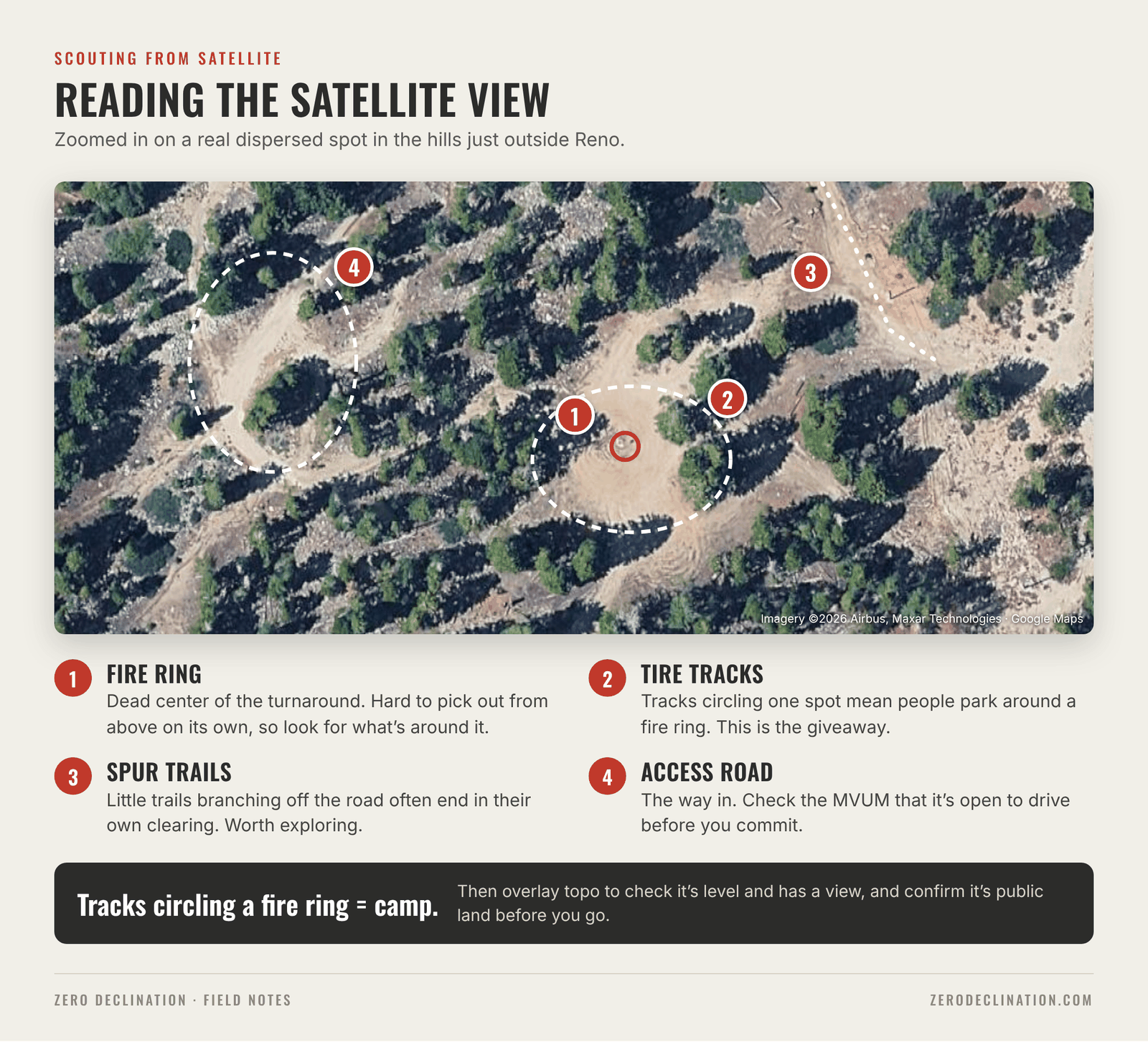
This is where it gets fun. Once you know an area is public land, pull up satellite imagery in Google Maps or Google Earth and go looking.
What you're looking for:
- A flat clearing just off a dirt road.
- A fire ring. Imagery is good enough now that you can often see them. Tire tracks circling one spot almost always mean a fire ring in the middle, and that's a camp. Guaranteed.
- Little spur trails off the main road that dead-end in a clearing. Ken and I have both found some of our best spots this way, and somehow those always have the best view.
Then overlay the topo in onX or Gaia. Contour lines tell you whether it's level enough to sleep on and whether you'll be looking out over a valley or into a hillside.
When you get there, look before you commit. Check that it's level, there are no closure signs, and you can get back out the way you came in.
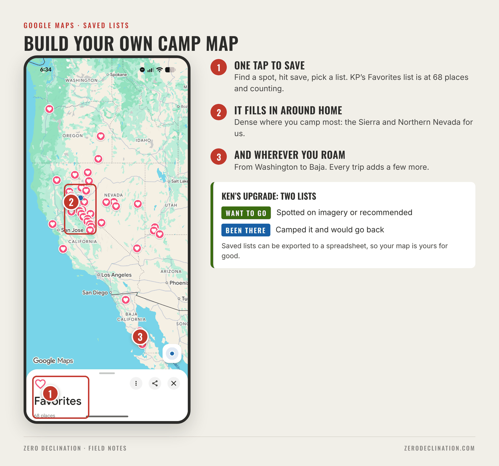
5.Build your own map
People always ask what I use to navigate, even across borders on motorcycles and trucks. They're always a little disappointed when I tell them: just Google Maps. It works really well.
The real trick is saving pins. Ken's Google Maps is covered in them: off-road shops, car parts, food, and camps, everywhere from LA to Japan. His system is simple:
- Want to go → one list (green on his map)
- Been there → another list (starred)
Mine works the same way. I save spots I've camped, spots I've spotted on imagery and want to check, and spots people have recommended. Next time I'm in the area, the options are already waiting.
It's free, it's on every phone, and your saved lists can be exported to a spreadsheet, so you never lose them. Every trip makes the next one easier.
Bonus: Ken's trick for camping near water
Ken loves a camp near water, and a friend tipped him off to a source most people never think of: the US Geological Survey (USGS). Its maps and data mark where springs are, sometimes down to the water temperature.
It takes a little detective work: cross-reference the springs with public land and a road that gets you close. That's exactly why it works. When you find the spot you were hunting for, it feels rad, and it's usually just you.
Ken's leaving the rest of that one to you.
- Search "campgrounds." A Forest Service or BLM campground means dispersed camping nearby.
- Ask a local.
- Confirm it's public land and check the local rules.
- Check iOverlander and the topo apps.
- Scout the satellite view for a clearing, a fire ring, and tracks.
- Save it to your map.
And as Ken put it at the end of our chat: don't camp in our spots.
Follow Ken's adventures at @iamkenjo and see his work at Hot Visuals. For more guides from the shop, check the Resources tab at zerodeclination.com.